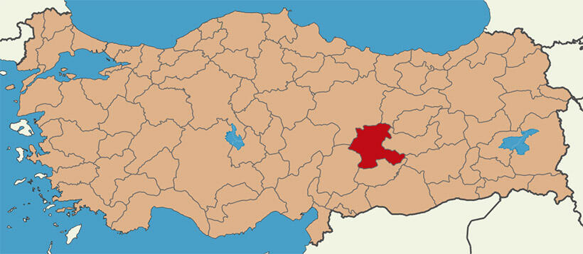
Malatya; Doğu Anadolu Bölgesi’nin Yukarı Fırat Havzasında ve Adıyaman, Malatya, Elazığ, Bingöl, Muş, Van çöküntü alanının güneybatı ucunda yer almaktadır. Çevresini doğuda Elazığ ve Diyarbakır, güneyde Adıyaman, batıda Kahramanmaraş, kuzeyde Sivas ve Erzincan illeri çevirir. il topraklarının yüzölçümü 12.313 km2. olup, 35 54' ve 39 03' kuzey enlemleri ile 38 45' ve 39 08' doğu boylamları arasında kalmaktadır. Malatya, Sultansuyu ve Sürgü çayı vadileri ile Akdeniz’e, Tohma vadisi ile İç Anadolu’ya, Fırat vadisi ile Doğu Anadolu’ya açılarak bu bölgeler arasında bir geçiş alanı oluşturur.
Malatya il alanı, Alp kıvrımlaşması sonrasında şekillenmiştir. Daha sonra III. Jeolojik zamanın sonuyla IV. zamanın başlarında ortaya çıkan tektonik hareketler sırasındaki kırılma ve kıvrılmalarla kimi kesimleri yükselmiş ya da çökmüştür. İl alanında çok şiddetli aşınmalar olmuş, çöküntü alanları alüvyonlarla dolmuştur. Başta Malatya ovası olmak üzere ilin diğer ovaları bu gelişmelerle ortaya çıkmıştır. Bu nedenlerle il alanında III. zaman yaşlı kalker ve konglomeralar, volkanik küller çok yaygındır. Malatya ovası, yükseltileri 1500 metreyi aşan dağ sıraları ve platolarla çevrili, geniş bir çöküntü alanıdır. Yükseltisi 915950 metre arasında değişen bu çöküntü alanının kuzeyi beyaz ve yeşil marnlarla kaplıdır. Bu oluşumların üzerinde kuzeye eğimli göl kalkerleri yer alır. Ovanın kuzey doğusunda ise kuzeybatı yönüne doğru uzanan andezit lavları ile tabakalaşmış beyaz ve yeşil marnlar göze çarpmaktadır. Çöküntü alanının güneyi III. zaman eosen kalker serileri ile örtülüdür. Kuzeye doğru eyimli bu yapı, il merkezinin güneyinde mikaşistlerle tabakalaşmış, mermerleşmiş, kalkerlere dönüşür. İl merkezi ile Malatya dağlan ve Fırat vadisi arasındaki alana IV. zamanda taşınarak oluşmuş eski alüvyonların altında III. zaman yaşlı gabbrove granodiyoritler uzanmaktadır. İl alanının güneybatı ve batısında III. zaman neojen kalkerleri egemen durumdadır. 5060 metre kalınlıkta yatay tabakalar oluşturan aynı yaştaki konglomeralar Tohma, Sultansuyu ve Kuruçay vadilerine doğru sokulurlar.
Malatya’da hemen hemen tüm büyük toprak türlerine rastlanır. Büyük kesimi dik evim, sağlık ve erozyon nedeniyle sorunlu olan bu toprakların başlıcaları ve özellikleri şöyle sıralanabilir.
İl alanında değişik yaşlı kireç taşlarının üzerini koyu, organik madde yönünden zengin kahverengi orman toprakları kaplar. Bu olgun topraklar, hafif eğimli kesimlerde kalın, daha eğimli kesimlerde ise ince tabakadır. Bu topraklar yükseltinin 1000-2000 metre arasında değiştiği ve yıllık yağış ortalaması 7800 mm’nin üzerinde olan alanlarda yayılır. Yağış miktarının yeterli olmasına rağmen, ayrışmaya dayanıklı ve yüzeye paralel olarak uzanan kireçtaşı tabakası, derin toprak oluşumunu engellemektedir. Malatya dağlarının batı kesimlerinde, değişik şistlerle başkalaşım serileri üzerinde ve orman örtüsü altında kireçsiz kahverengi orman toprakları oluşmuştur. Bu olgun toprakların yapısında serbest kireç yoktur. Topraklar daha eğimli kesimlerde yarı olgun durumdadır. Ayrışma ve organik madde birikimi ile oluşmuş üst toprak dışında pek tabakalanma da yoktur. Bu toprakların yayılım alanında yıllık yağış ortalaması 600 mm’nin üzerindedir.
Doğal örtüyü yapraklı ağaçlardan meşe, ibrelilerden bodur ardıçlar ve kızılçamlar oluşturur, ilde orman kuşağından kurak kuşağa geçişte volkanik oluşumlu alanlar, yer yer kireçsiz kahverengi tapraklarla örtülüdür. Bu olgu topraklar, aşınınım pek şiddetli olmadığı kesimlerde de hayli derindir. Yayılım alanında yıllık ortalama yağış 400 mm dolayındadır. Doğal bitki örtüsü alan bakımından olmasa da, nitelik açısından ildeki en önemli toprak grubu alivyonlu topraklardır. Malatya ovası ve bu ovanın devamı durumundaki düzlüklerle Fırat, Tohma, Sultansuyu, Sürgü ve Kuruçay vadilerindeki taban topraklan alivyonlarla kaplıdır.. Bu genç topraklar akarsularla taşınarak yatay biçimde istiflenmiş maddelerden oluşmuştur. Birikinti maddelerinin taşındığı yüksek alanlar genellikle değişik yaşlı kireç taşlarından oluşmaktadır. Arada yer yer dış püskürükler görülür. Bu ne denle bütün alivyonlu topraklar kireçlidir. Bu genç toprakların oluşumu için, özel iklim ve bitki örtüsü gerekmez. Kuru ve sulu tarla tarımı yapılan bu topraklarda, tahıl ürünleri sanayi bitkileri, meyve ve sebze yetiştirilmektedir. İlde, ovaların çevresindeki az eğilimli alanlarda, yer çekimi ve küçük akıntılarla taşınarak yığılmış maddelrin oluşturduğu kolüvyol topraklar vardır. Alivyonlu topraklarda olduğu gibi yatay tabakalanma görülmeyen bu topraklarda genellikle kuru tarım yapılmaktadır. Bu topraklarda başta tarım ürünleri olmak üzere meyve yetiştirilmektedir. ilde, bu toprak grupları dışında az bir alanda kırmızı Akdeniz toprakları hidromorfik alüvyol topraklar vardır. Ayrıca çıplak kayalıklar, ırmak kıyı kumulları ve ırmak taşkını yataklarına da rastlanır.
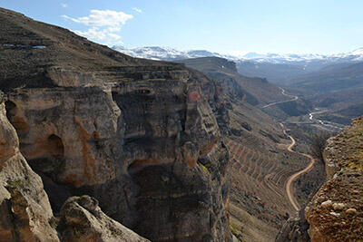
Dağlar
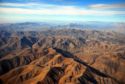
İl alanının büyük bir bölümü, III. jeolojik devirdeki Alp kıvrımlaşması sırasında şekillenen Güneydoğu Toroslarının kolları, ilin güneyini doğubatı yönünde baştanbaşa kaplar. Güneyde daha düzenli sıralar oluşturan bu dağlar doğrudan Tohma suyu aracılığı ile ya da Fırat’a katılan çok sayıda akarsuyla sıkça parçalanmıştır.
Malatya’daki Dağlar
Güneydoğu Torosları, Gaziantep Gölbaşı’nın kuzeyinde yer alan Kapıdere boğazından sonra çeşitli kollara ayrılır. Dağ kütlesinin güney kolunu oluşturan ve batı-doğu yönünde uzanarak Besni, Adıyaman ve Kâhta ile Malatya ovasını dolduran dağlara Malatya dağları adı verilir. Yüksek ve çok dalgalı olan Malatya dağları çeşitli yönlerde inen akarsularla parçalanmıştır. Bu sebeble Malatya dağlarında önemli düzlükler yoktur. Doğanşehir ovasının doğusunda düzenli sıralar oluşturmaya başlayan bu dağlar, Fırat vadisine kadar zaman zaman genişleyerek, zaman zaman daralarak uzanır. Malatya dağlan üzerindeki en önemli doruklar, batıdan doğuya doğru 2100 Korudağ, 2.424 Karakaya Tepe, 2.006 Becbel Tepe, 2.544 Beydağı, 2.150 Kelle Tepe, 2.306 metre yükselti Gayrık Tepedir.
Nurhak Dağlan
Sultansuyu vadisinin batısında ve Kahramanmaraş topraklarından il alanına giren Nurhak dağları, Güneydoğu Torosları’mn kuzeye açılan kolunu oluşturur. Vadiye paralel olarak kuzeydoğu yönünde uzanan bu dağlar Tohma vadisi ile bölünür. Aynı zamanda, batıya ve kuzeybatıya doğru açılarak, Tohma havzasını batıdan kuşatır. Nurhak dağlan üzerindeki en önemli yükseltiler şunlardır. Derbent dağı (2.428 m.) Kepez dağı (2.140 m.) ve Kuşkaya Tepesi (1.922 m.), Akçadağ (2.013 m.). Malatya ovası, Tohma vadisi, Darende ve Doğanşehir arasını bütünüyle kaplayan Nurhak dağları ve uzantıları, yeryüzü şekilleri bakımandan Malatya dağlarından değişiktir. Malatya ve Doğanşehir ovalarıyla, Tohma, Sultansuyu vadilerine göre yaklaşık 500 metre yükseklikte çok dağlı bir yeryüzü şekli oluşturan bu dağlar, genellikle volkanik kökenlidir. Bu dağlardan kaynaklanan akarsular, doğuda Sultansuyu’na doğru akarak derin vadiler oluştururlar. Yükseklik çağunlukla 2000 m’nin altındadır.
Akçababa Dağları
Tohma vadisi ile Kuruçay vadisi arasında yer alan bu dağlar, Nurhak dağlarının kuzey doğuya doğru sokulan uzantıları durumundadır. Pek yüksek olmayan Akçababa dağları, kuzeybatı yönünde yayılarak geniş bir alanı kaplar. Genellikle çıplak olan bu dağlar güneybatıdan kuzeydoğuya doğru Kuyucakbaşı Tepe (1.734 m.), Akçababah Tepe (1.164 m.), Ahbaba Tepe (1.857 m.) ve Leylek Dağı (2.052 m.) dir.
Yama Dağı
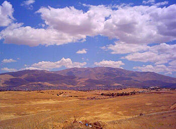
Büyük bölümü Sivas il alanında bulunan Yama dağı kütlesi güneye ve güneydoğuya doğru açılarak Malatya’nın kuzeyini bütünüyle kaplar. Batıda Kuruçay vadisine, güneydoğuda Fırat vadisine kadar uzanan Yama dağı ve uzantıları genellikle volkanik yapılıdır. Yüksekliği 1500 metrenin üzerindedir. Bu dağlar geniş, toplu ve yüksek bir kabartı oluşturmaktadır. Önemli doruklar dışında bu kesim, genellikle bir plato görünümündedir. Bu sıranın en önemli yükseltileri Arguvan’m batısında 1516 metre yükseltili Doyukan tepe, Kozdere’nin doğusunda 2.310 metre yükseltili Hasbek tepe ve Arapgir’in batısında 2.402 metre yükseltili Göl dağı’dır. Bundan başka doğuda Venk ve Izollu dağları, Pütürge ile Izollu arasında Şakşak, Pütürge’de Kubbe, Akdoğan; Arguvan-Arapgir arasında Çangal Aynaca, Eğerli; Hekimhan yöresinde Demirli, Kızılhisar, Zürbehan; Darende yöresinde Hezanlı, Ademkıran, Alidede, Heyik, Kuduz, Beynamaz dağı; Yeşilyurt yöresinde Karadağ, Karataş, Keklicek, Akseki dağları ile; Akçadağ yöresinde Öğlekayası, Kartal Kaya ve Kurugöl gibi dağlarla tepeler vardır.
Malatya il alanında platolar çok geniş yer tutar. Genellikle kalker yapılı olan dağlar, hızla aşınarak orta ve yüksek platolara da dönüşmüştür. Volkanik hareketler sonucu çıkan lavlar dalgalı yapıyı düzleştirerek geniş düzlüklerin ortaya çıkmasına sebep olmuştur.
Güney Platoları
Malatya dağları üzerinde sıralanan platolardır. Burada, dağlar yüksek ve düzenli sıralar oluşturduğundan kuzey ve batı yamaçlarında çeşitli yükseltilerde alt alta, ya da yan yana dizilmiş platolar vardır. Bu platolar su kaynakları bakımından zengindir.
Batı Platoları
Batı platoları, güney platolarına göre daha alçak yükseltide olup, yükseltileri 1500 metrenin üzerine çıkmaz. Yörede dağlar, düzenli sıralar oluşturmayan tek tek kütleler durumundadır. Tohma suyu ve kolları ile parçalanmış ve oldukça derin vadiler arasında sıralanan platolar, genellikle kuru ve çıplaktır. Bu platolar Aygörmez ve Kepez dağlarından, Tohma vadisine, Akçababa dağlarından Tohma ve Kuruçay vadilerine doğru yükselti kaybederek sıralanır.
Kuzey Platolar
Malatya’nın en önemli platolarıdır. Yama dağının eteklerinde sıralanan ve Yama Platoları adıyla da anılan yüksek düzlükler Fırat vadisine doğru ilerler. Kuzey platolarının, Sivas sınırlarına yakın kesimleri daha geniş ve düzdür. Bu sebepten buradaki platolar daha küçük ve değişik yükselti basamaklarına dizilmiş taraçalı bir yapıdadır.
Vadiler ve Ovalar
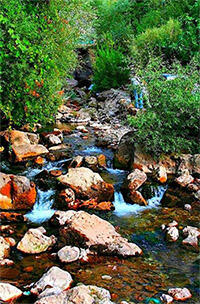
Malatya il alanında vadilerin önemi büyüktür, ildeki bütün vadiler Fırat ana vadisine açılmaktadır. Bunlardan özellikle Tohma vadisi, yan vadileri ile geniş bir ağ oluşturur. Bu vadilerin tabanları Fırat vadisine yaklaştıkça genişler ve ilin önemli ovaları ortaya çıkar. Bu vadilerin büyük bir bölümü günüümüzde Karakaya Baraj Gölü alanında kalmıştır. Öbür vadiler de yer yer genişleyerek çeşitli yükselti basamaklarında sıralanan büyüklü küçüklü düzlükler oluşturur.
Malatya Ovası, Doğanşehir Ovası, İzollu Ovası, Mığdı Ovası, Sürgü Ovası, Akçadağ Ovası, Yazıhan Ovası, Mandara Ovası, Çaplı Ovası, Distrik Ovası ve Erkenek Ovalarıdır.
Malatya Ovası
Tohma, Sultansuyu ve Fırat vadileri arasında kalan çok geniş bir alanı kaplar. Ortalama yükseltisi 900 m. olan bu geniş düzlük, kademe kademe yükselen ve 1500 m. ye kadar çıkan platolarla, yüksek dağlarla çevrilidir. Ovanın yüzölçümü 830 km2'yi bulur. Batı-doğu yönünde uzanan Malatya Ovası bir çöküntü alanıdır. Akarsuların alüvyonları ile dolması sonucu oluşmuştur. Akarsuların taşıdığı bu genç dolgu maddelerinin kalınlığı 50 ile 100 metre arasında değişmektedir. Dolgu tabakasının kalınlığı, ovanın kenarlarına doğru incelir. Ova genellikle düzdür. Ancak çevreden inen küçük akarsuların vadilerinde derinlik 60-100 m.ye ulaşır. Böylece hafif dalgalı bir yapı oluşmuştur. Malatya Ovası, kalın bir toprak tabakası ile kaplı olup, verimlidir. Çok geçirgen olduğundan su tutmaz ve çabuk kurur. Bu nedenle, tarımsal üretim açısından sulama son derece önemlidir. 1975'de Tohma üzerinde yapılan Medik Barajı, Sultansuyu ve Beylerderesi’neden yararlanılarak bazı alanlar sulamaya açılmıştır.
Doğanşehir Ovası
Tohma vadisine güneyden açılan Sultansuyu vadisinin her iki yanma sıralanmış, küçüklü büyüklü düzlüklerin tümüne birden Doğanşehir Ovası adı verilmektedir. Ova Suçatı’ndan sonra Doğanşehir’e doğru daralmaya başlar. îlçe merkezinde yükselti 1.250 metreye ulaşır. Sultansuyu ve kolları ovadan pek derin olmayan yataklarda akar.
İzollu Ovaları
Malatya ovasının doğusunda Fırat nehrinin dar ve derin bir koridor oluşturduğu Kömürhan boğazına kadar uzanan kesimindeki, irili ufaklı düzlüklere Izollu ovaları adı verilmektedir. Bunlar, Malatya dağlarından başlayarak kuzeydoğu yönüne uzanarak Karakaya baraj gölüne doğru açılan taraçalı düzlükler durumundadır.
Erhaç Düzü ile Arga ve Ören Yazıları
Malatya ovasının batıya doğru uzantıları durumunda olan bu düzlükler yer yer dalgalı ovalardır. Sultansuyu vadisi ile Tohma vadisi arasında kalan üçgen biçiminde alanı dolduran bu düzlüklerin yükseltisi, Malatya ovasına göre daha fazladır.
Mandıra, Tafta ve Milli Yazıları
Yarı ova nitelikli alanlardan Mandıra düzü, Sultansuyu ile Beylerderesi arasında; ötekileri ise, Beylerderesi doğusunda kalmaktadır. Malatya ovasının güney uzantıları durumundaki bu alanlar, daha yüksek ve daha dalgalıdır.
Mığdı Düzü
Ayvalı, Tohma ile Hacılar Tohması vadilerinin birleşme noktasında yer alır. Darende’nin doğusunda ve güneydoğusunda geniş bir alanı kaplayan ovanın yüzölçümü yaklaşık 50 km2'dir. Ovanın orta kesimleri düz olup, kenarlara doğru yükselti artar ve dalgalı bir yapı ortaya çıkar. Genişleyen vadi tabanı akarsuların taşıdığı alüvyonlarla dolması sonucu oluşan toprak, verimli bir durumdadır. Yeşil örtü, yalnızca su kenarlarında söğüt ve kavak ağaçlarından oluşur.
Fırat Vadisi
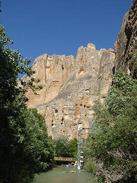
Türkiye’nin en önemli vadilerinden birisidir. Çok derin ve sarp olan Fırat vadisi, keskin dirsekler çizerek uzanır. Sarplaşan vadi, bu yapısını Malatya topraklarında Söğütlü çayı vadisi ile birleşene kadar sürdürür. Bundan sonra vadi genişlemeye başlar. Akarsu, çok geniş bir yatakta akmakta iken zaman zaman kollara ayrılarak adacıklar olurşutur. Göldağı ve Sarıçiçek yaylası hizasından sonra yapı birden değişir. Fırat vadisine doğru eğimli geniş oluklar ortaya çıkar. Bunlar, Tohma ve Kuruçay vadileridir. Fırat vadisinin bu yapısı, Malatya dağları nın doğu ucuna kadar sürer. Burada vadi yeniden daralır. 100 km. den uzun bir boğaza dönüşür. Kömürhan Boğazı adıyla anılan bu boğazdan sonra vadi, il topralarmın dışanı çıkar.
Tohma Vadisi
Sivas topraklarından iki kol halinde başlayan Tohma vadisi, Fırat vadisine doğru geniş bir oluk oluşturur. Darende yanından bu kollar genişlemeye başlar. İlçenin doğusunda birleşir. Vadilerin birleşme yerinde geniş bir düzlük oluşur. Mığdı düzü adıyla anılan bu yüksek ovadan sonra vadi, biraz daralarak doğu yönünde uzanır. Sonra güneyden gelen Sultansuyu vadisi ile birleşerek birden genişler ve Fırat vadisine açılır. Genişleyen vadi tabanında, ilin en önemli düzlüklerinden Malatya ve Doğanşehir ovaları ile Erhaç düzü ve Yazıhan düzü sıralanmaktadır.
Kuruçay Vadisi
Yama dağının batı eteklerinden başlayan vadi, başlangıç kesimlerinde pek derin değildir. Tohma vadisinde sıkça rastlanan sarp ve dar boğazlar yoktur. Bunun başlıca sebebi yöredeki, aşınarak yuvarlanmış yeryüzü şekilleridir. Ayrıca vadiyi aşan akarsuyun havzası küçük ve akıttığı su miktarı da azdır. Yine Kuruçay vadisi orta bölümünde biraz daralır. Daha sonra tabanı genişleyerek Tohma ve Fırat vadileri ile birleşir. Kuruçay vadisinde Ça-pıtlı yazısı ile Yazıhan düzü dışında ovalık alan yoktur.
Çapıtlı yazısı
Kuruçay vadisinde, Hasançelebi yöresini kaplayan düzlüğe Çapıtlı yazısı denir. Akgedik diplerinden Hasançelebi’ye doğru uzanan bu yüksek ovanın boyu 20 km.yi geçer. Genişliği 10 km. ye ulaşır. Ova, genelde düz olmakla birlikte, yer yer hafif dalgalı bir yapıdadır.
Yazıhan Düzü
Bu ova, Tohma ve Kuruçay vadilerinin Fırat’a açıldığı noktada yer alır. Malatya ovasından Tohma suyu ile ayrılır. Tohma suyunun kuzeyinde kalan ve Kuruçay vadi tabanını da kapsayan alanın bütününe Yazıhan düzü denilmektedir. Mayatya ovasına göre daha yüksekte kalan Yazıhan düzü su kaynakları kıt olduğundan kuru ve çıplaktır. Tohma suyu ova yüzeyine göre derinde kalmaktadır. Kuruçay ise yaz aylarında kurumaktadır.
İlimizin başlıca akarsuları; Söğütlü Çayı 17.5 km., Morhamam Çayı 22.5km., Kuruçay 67 km.Tohma suyu 52.5 km., Sultansuyu 21.5 km., Sürgü suyu 30 km., Beylerderesi 38 km., Mamihan çayı 10 km., ve Şiro çayı 37 km. dir.
Söğütlü Çay
Göl dağının güney yamaçlarından başlayan bu vadi pek uzun değildir. Önce güneye, sonra güneydoğuya uzanarak Fırat’a açılmaktadır. Vadi yer yer genişleyerek büyük olmasa da tarım açısından önemli ovacıklar meydana getirmektedir. Bunların başlıcaları; Dişt-rik ve Arguvan yazılarıdır. Diştrik yazısı, Söğütlü çay vadisinden Mutmur bucağı vadisine doğru yayılan düzlüğe denilmektedir. Küçük bir ovadır. Uzunluğu ve genişliği 17.5 km.ye ulaşan ova, yer yer dalgalı ve taşlıktır.
Arguvan Yazısı:
Söğütlüçay vadisi Arguvan yakınında genişler, burada uzanan düzlüğe Arguvan yazısı adı verilmektedir.
Sürgü Vadisi
Göksu vadisinin başlangıç bölümünü oluşturan bu vadi, Karakaya tepenin güney yamaçlarında başlamakta, 20-30 km. aynı yönde uzadıktan sonra, önce batıya, sonra güneye ve güneydoğuya doğru genişçe bir yay çizerek il dışına çıkmaktadır. Daha sonra Göksu vadisi adı altında Adıyaman topraklarını geçip Fırat vadisine açılmaktadır. Vadide ilin tarım bakımından önemli olan Sürgü ovası yer almaktadır.
Sürgü Ovası
Malatya çöküntü alanının güneybatı ucunda yüksek bir ovadır. Genişleyen vadi oluğunun akarsuların taşıdığı alivonlarla dolması sonucu oluşan topraklar çok verimlidir. Sürgü çayı üzerine kurulan Sürgü barajından sulanmaktadır. Malatya ovasına göre daha yüksekte kaldığından kışlar biraz sert geçmektedir.
AKARSULARI
Malatya ili, Fırat havzası üzerinde yer alır. Havzanın yukarı Fırat bölümünüde oldukça geniş alanı kaplayan il toprakları, yer üstü su kaynakları açısından hayli zengindir.
Fırat Havzası
Türkiye’nin en büyük havzasıdır. Su toplama alanı 127.000 km2 dolayında olan havzanın yıllık ortalama su hacmi 28 milyar m3'ü aşmaktadır. Fırat havzasında 4.900.000 hektara yakın ovalık alan vardır. Bunun 1.700.000 hektar yer alan akarsuların en önemlileri Tohma suyu, Kuruçay, Fırat nehri ve Sürgü çayıdır.
Fırat Nehri
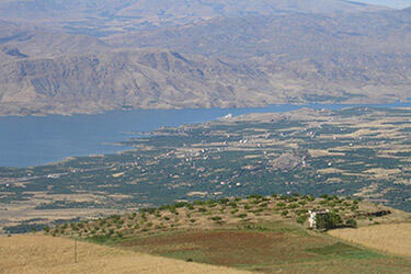
Keban Barajı’ndan çıkan nehir Malatya’nın Elazığ ile sınırını oluşturacak şekilde güneybatıdan güneydoğuya doğru genişçe bir yay çizerek akar. Önce Kuruçay’ı sonra Tohma suyunu alarak akan Fırat, zaman zaman kollara ayrılarak adacıklar oluştururdu. Bu alan günümüzde Karakaya Baraj Gölü sahası içinde kalmıştır. Fırat nehri, Kömürhan mevkiinde Doğu Anadolu’nun en uzun ve en derin boğazlarından biri olan Kömürhan boğazına girerek akmasına devam edip, boğazdan sonra Malatya-Diyarbakır sınırını oluşturmaktadır. Diyarbakır Çüngüş ilçesi yakınlarında Karakaya Barajı kurulmuştur.
Tohma Suyu
Malatya’nın doğu sınırını oluşturan Fırat nehrinden sonra ilin büyük akarsuyu Tohma’dır. iki koldan oluşmaktadır. En uzun kolu olan Ayvalı, Tohma çayı, Uzunyayla’dan diğer kolu olan Hacılar Tohması ise Tahtalı dağlarından doğar. Bu iki kol Malatya il sınırına girerek Mığdı üzerinde birleşip dar ve uzun Şuğul boğazından geçtikten sonra Malatya ovasından geçerek Fırat nehrine katılır. Tohma suyunun Şuğul boğazından kurtulduğu yerde Medik barajı kurulmuştur. Tohma suyu Malatya ovasından akarken kuzeyde Halavun çayı ile Epreme çayı, güneyde Dipsiz çayı, Sultansuyu, Beylerderesi Horata çayı ile Orduzu çayını alarak Fırat nehrine dökülmektedir. Bu sular Sultansuyu, Doğanşehir ve Malatya ovalarının sulanmasında önemli yer tutmaktadır.
Kuruçay
Yama dağı batısından doğan Kuruçay, Hasançelebi, Hekimhan ve Fethiye’yi geçtikten sonra Eğribük yönünde Fırat’a katılır. Yaz aylarında suyu iyice azaldığından bu sudan pek faydalanılamamak-tadır.
Sürgü Çayı
İlin güneybatı ucunu oluşturan Sürgü yöresinin sularını toplayan bu çay, Malatya yöresinin batı kesimlerinde yer alan Karakaya tepesinin güney yamaçlarından doğar. Sürgü çayı, Göksu ırmağının önemli bir koludur. Sürgü kasabasından sonra, Kapıdere’ye kadar batı yönünden akan çay sonra güneye döner. Burada, Göksu ile birleşen ve Göksu adını alan akarsu, doğuya dönerek Adıyaman il sınırına girerek Adıyaman il topraklarından Fırat’a katılır. Sürgü çayı üzerinde Sürgü barajı kurulmuş olup, bu barajdan geniş bir alan sulanmaktadır. Malatya’nın bu önemli akarsuları dışında ya doğrudan Fırat’a, ya da diğer büyük akarsulara karışan çok sayıda küçük çay ve dereleri vardır. Bunlar: Eğmir, Mircan, Göksu, Aksu, Şiro, Berenge, Söğütlüçay, Sazdere, Şotikdere, Kozluk Çayı, Yenice Çayı, Setrek Çayı, Arapgir ÇAayı, Davulga, Cevizlisu gibi irili ufaklı akarsulardır.
İlimizde Sürgü, Medik, Polat ve Sultansuyu barajları olmak üzere 4 baraj bulunmaktadır. Polat ve Sultansuyu barajları sulama amaçlı, Medik Barajı Sulama + Elektrik amaçlı ve Sürgü Barajı da Sulama + Taşkın koruma amaçlı olarak inşa edilmiştir. Sultansuyu barajı 1993'te hizmete açılmış olup, en yeni barajımızdır. 1996 yılında Çat barajının da hizmete açılması beklenmektedir.
Malatya’da önemli bir tabii göl yoktur. Yalnızca dağlık kesimlerden akan suların kaynak alanlarında ve düşük yükseltiri plato basamaklarında yüzeye çıkan suların oluşturduğu küçük göller vardır. Bunlar dışında sulama amaçlı 5 gölet vardır. Bunlardan; Orduzu Sulama Göleti, Orduzu Zorbalı Sulama Göleti ve Hançayı II. Sulama Göleti, Malatya Merkezde, İsaköy sulama göleti Arguvan ilçemizde; bir sulama göleti de Darende ilçemizde bulunmaktadır.
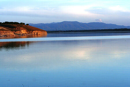
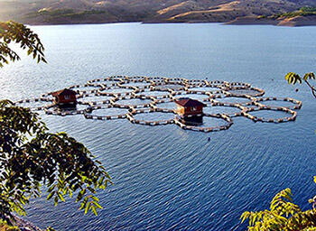
Karakaya Baraj Gölü
Malatya merkez ilçesinde 42, Pütürge ilçesinde 15, Akçadağ ilçesinde 2, Arguvan ilçesinde 6, Arapgir ilçesinde 2 köy olmak üzere toplam 67 köy göl alanı içerisinde kalmış olup, baraj gölü Malatya il sınırları üzerinde 150.875.583 m2'lik bir alanı kaplamaktadır.
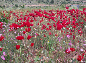
Malatya toprakları önemli bitki örtüsünden yoksundur. Eskiden il alanının önemli bir bölümü ormanlarla kaplı iken sonucu bu örtü zamanla yok olmuştur. Doğal şartlar ormanların kendi kendisini yenilemesini büyük ölçüde güçleştirdiğinden yer yer bozkırlar ortaya çıkmıştır.
İl arazisinin 367.253 hektarı (% 30)’u ormanlık ve fundalıklarla, 125.156 hektarı (% 10)’u ise çayır ve meralarla kaplıdır. îl topraklarının güneyini boydan boya kaplayan batı-doğu doğrultulu Malatya dağları, meşenin egemen olduğu bozuk nitelikli korular ve baltalıklar iyi nitelikli koru ve baltalıklara dönüşmeye başlar. Malatya dağlarının batı ucunda Sultansuyu vadisine bakan yamaçlarda Doğu Anadolu’da ortadan kalkmakta olan ibrelilerden kızılcıklara rastlanır. Malatya dağları üzerinde yer alan platolar ile Malatya ovasına yakın kesimlerede yer alan yarı ova nitelikli düzlükler, zengin çayır otları ile kaplıdır. İl alanının güneybatısını kuşatan dağlar ve platolarda doğal bitki örtüsü hemen hemen ortadan kalmıştır. Daha çok meşelerden oluşan bozuk nitelikle orman kalıntılarından başka canlı örtüye rastlanamaz. Bu örtüye yer yer yabani meyve araçları ile kaynak ve vadi boylarında kavak ve söğütler katılmaktadır. Bitkisel üretim yapılan kesimlerde meyvecilik doğal örtüye göre daha yaygındır. Malatya’nın kuzeyini kaplayan dağlar ise örtü bakımından Pütürge ve Doğanşehir yöreleri kadar olmasa da batıya göre daha da zengin sayılır. Bu yörelerede, çoğu bozuk nitelikli olmak üzere meşenin çoğunlukta olduğu yapraklı ormanlar vardır. Bu kesimde kalın bir toprak tabakası ile meyve ağaçları, söğüt ve kavaklıklar görülür.
{{item.description[0].name}}